Methods:
Part 1: Bear habitat suitability modeling
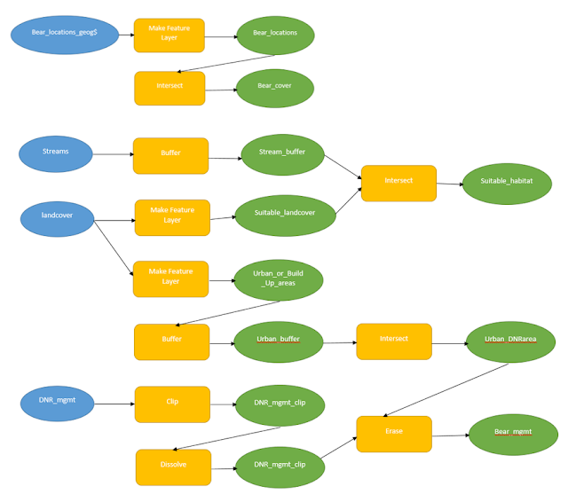
Having the data model explained, you first need to create a shapefile out of the bear_locations_geog$ data in the spreadsheet. Then you intersect the bear_locations with landcover to create the bear_cover shapefile.
After that you take the streams shapefile and create a 500 m buffer around it. Then from the landcover make a layer out of the suitable_landcover. Intersect the stream_buffer and the suitable_landcover to make the suitable_habitat for the bears.
Add the DNR_mgmt shapefile to show the areas that the DNR focuses on in the county. Clip the shapefile to only get the DNG_mgmt in the study area. Dissolve the new layer to get ride of the gird areas and just have the general areas visible.
After that Use the landcover again to create a layer with Urban or Built Up Areas. Intersect the buffer around the urban areas with the DNR_mgmt that was clipped and dissolved. Then erase new shapefile with the urban buffer to create the bear management area that is within the DNR management and is also away from the Urban areas.
Part 2: Scenario 1 - Finding suitable areas for the development of tourist resorts
The model above is the data flow model of how to create the map. To find an area that is a lake that is above 5 square miles in area and also not more than 10 miles from a city. To complete the action, use the Python code that is provided in the Python box below.
Part 2: Scenario 2 - Modeling air pollution impact zones
When the multiple ring buffer is complete, in the symbology change the 6 names of the rings ranging from Very High to Low in distinct colors do show the 1 mile buffer zones.Results:
This is a map of a study area that is located in Marquette County, Michigan. It includes the sustainable habitats for bears to potentially live in based on two criteria: the top three types of land, and a buffer around the streams. It shows the locations of bears and DNR management areas that are away from Urban living.
The map include the counties in which Wisconsin that have lakes that are qualified for tourist
resorts. These lakes had to be greater than 5 square miles.
In the state of Wisconsin, areas are being looked within six miles of an interstate to account for air pollution
problems, suggesting that the pollution higher the closer you get to the interstate. The buffer shows six zones of potential air quality problems at one mile interval.
Sources:
Environmental Systems Research Institute. (2016).
Michigan Department of Natural Resources. (2016). Marquette
County, Michigan GPS Location of Black Bears.
Price, M. (2016). Mastering ArcGIS. 7th Edition
data. McGraw Hill.
Wilson, C. (2012). A comprehensive Lake features
for Wisconsin. Unplublished Data.


No comments:
Post a Comment