Methods: For numbers 1 through 3 (Part 1), I used the USA geodatabase from the Price mgisdata that was previously given to us. Add the counties shapefile from that geodatabase. Create a query under Selection > Select by Attributes to create the expression. The expression should include POP2010 > 3000 AND POP2010 < 4000 AND POP10_SQMI >= 1000. Create a layer from selected features to show clearly was has been selected on the map that is created of the continuous US next. Make sure the map includes Counties, Title, Legend, Map Scale and North Arrow.
For the number 2 repeat sections of number one but change the expression to (STATE_NAME = 'Wisconsin' OR STATE_NAME = 'Texas' OR STATE_NAME = 'New York' OR STATE_NAME = 'Minnesota' OR STATE_NAME = 'California') AND AGE_65_UP > 6500 AND MALES > FEMALES
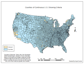
Number 3 is an addition to the expression for the query in number 2. The final expression should be (STATE_NAME = 'Wisconsin' OR STATE_NAME = 'Texas' OR STATE_NAME = 'New York' OR STATE_NAME = 'Minnesota' OR STATE_NAME = 'California' OR STATE_NAME = 'Washington' OR STATE_NAME = 'Maryland' OR STATE_NAME = 'Illinois' OR STATE_NAME = 'Nebraska' OR STATE_NAME = 'District of Columbia' OR STATE_NAME = 'Michigan' ) AND AGE_65_UP > 6500 AND HSE_UNITS > 30000 AND MALES > FEMALES
Part 2 (numbers 4-5) uses the Wisconsin geodatabase that was provided. Add counties, cities, and lakes shapefile.
Number 4 asks that the query (Selection > Selection by Attributes) contains the expression POP2007 > 15000 AND POP2007 < 20000 AND AREALAND > 5 AND FEMALE > MALE. Next go to Selection > Selection by Location and change the selection method to 'select from the currently selected features,' the target layer should be lakes and the source layer should be cities. Then make sure the spatial selection is within the distance of the source layer feature by 2 miles. Create a map of the selection which should include county, roads, and lake layers, then the title, legend, map scale, and north arrow.
Number 5 uses the counties and rivers shapefile. Use the 'Select by Attributes' again to only select the CHIPPEWA R, EAU CLAIRE R, 'EMBARRASS R, FISHER R, HUNTING R, KINNICKINNIC R, MAUNESHA R, MILWAUKEE R, MOOSE R, NAMEKAGON R, PELICAN R, PLATTE R, and POTATO R. By using the 'PNAME' = 'CHIPPEWA R' OR 'PNAME' = ... etc. for all of the selected rivers. This map should be compiled of the Wisconsin counties, major roads, lakes shapefiles and the usual map essentials.
Results:
Continuous United States showing the criteria of the population between 3,000 and 4,000 people in 2010 and all the counties that had a population density of at least 1000 persons per square mile.
Continuous United States focusing on the states Wisconsin, Texas, New York, Minnesota, and California where the male population is greather than the female population and includes the number of seniors (age 65 and up) that is over 6,500.
Continuous United States focusing on the states Wisconsin, Texas, New York, Minnesota, and California where the male population is greather than the female population and includes the number of seniors (age 65 and up) that is over 6,500. It also adds the states Washington, Maryland, Illinois, Nebraska, D.C. and Michigan that show the seniors and counties that have more than 30,000 housing units.
Cities in Wisconsin with a population between 15,000 and 20,000 people, area of the city is at least 5 square miles in land area, female population is greater than the males, and the those cities are within 2 miles of a lake.
Only shows the Chippewa, Eau Claire, Embarrass, Fisher, Hunting, Kinnickinnic, Maunesha, Milwaukee, Moose, Namekagon, Pelican, Platte, and the Potato River in Wisconsin.
Sources:
Price, Maribeth H.. Mastering ArcGIS (Seventh Edition).


No comments:
Post a Comment